Viewer Configuration
As an administrator of an organization, you can configure your LocalMaps Viewer’s look and behaviour through the admin panel. Here, you set the logo, colour, loading screen image, font and font color of your viewer. Settings for the basemap widget, elevation service to be used in the elevation profile widget and splash screen is set through the viewer in the admin panel.
Add Data Group
Data groups available in the Add Data Widget are pulled from this group.
Dimensions for images
For reference, these are the dimensions for the images used in the LocalMaps demo site. These are meant as a guide only, and you can adjust the dimensions to suit your needs.
- Favicon: 16px x 16px
- Gallery Logo: 600px x 425px
- Hero Heading: 2673px x 1017px
- Viewer Logo: 600px x 425px
- Loading screen: 1048px x 800px
Configuring Splash Screen
You can enable splash screens to appear before viewing any map through the LocalMaps viewer. This can be used to add any disclaimer or read me text for the users.
Configuring the text to appear within the splash screen (to be configured through Portal or ArcGIS Online)
The text that appears in the Splash Screen comes from that specific map’s Terms of Use in the Item Page. To configure this, open the specific map through Portal for ArcGIS or ArcGIS Online. Add the required text to appear under the Terms of Use section and save it. For more information, please refer to this article: Item Details.
Enable/Disable Splash Screens (to be configured through LocalMaps Admin panel)
- Check the box to enable it for the LocalMaps Viewer.
- Configure the type of Splash screen.
- Select the type of Splash screen you would like to configure:

- Don’t show again - Optional for users to confirm or not.
- Confirmation – Users need to click Confirm before seeing the map and information shared.
Elevation service
Elevation service is a URL that is used to provide elevation data for the Elevation Profile Widget. If you have a custom elevation service, you can add it here.
Print Settings
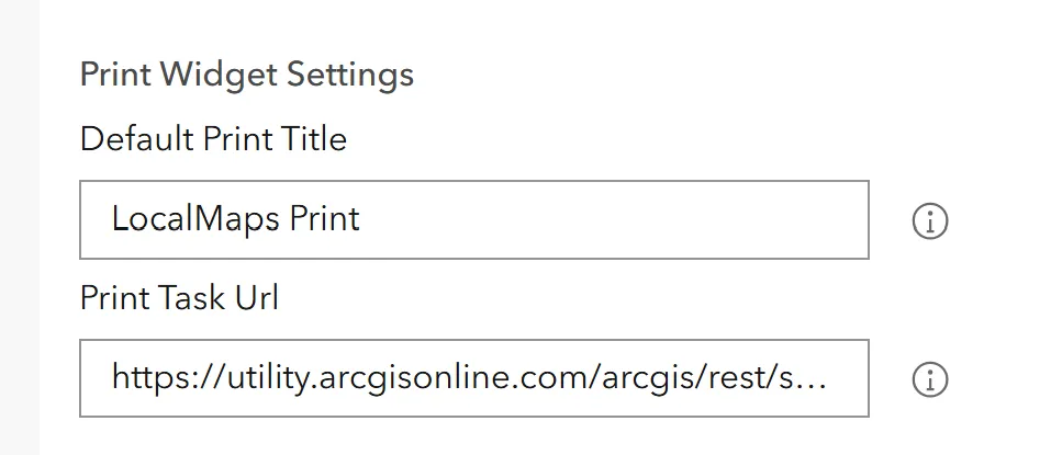
Here you can configure the print settings for the viewer

- Default print title: the default title that will show in the print widget textbox. This can be changed by the user within the map viewer Print Widget.
- Print task URL: The print service LocalMaps uses. This is used to print and preview maps in the print widget.
- Print layout URL: This is required to utilize the LocalMaps Print Preview Window. If your organisation has ArcGIS Enterprise Installed, you can generate your own Get Layout Templates Info Task. Alternatively, the Esri task can be used.
Customizing the Look of the Viewer
Within each of these, there are options to change the background color and font colors. Here is a quick guide to getting started:
-
Navigate to the admin panel and on the sidebar, click on Viewer. You will be presented with a range of customization options for each element of the page, which is broken into sections.
-
To set the font of the gallery, you have the option to select from presets or use a custom Google font. Clicking the dropdown menu will give you a list of presets to select. If you wish to use a Google font, simply type the name into the textbox and the font will be applied.
-
To change colors, do so by clicking on the color field, and you can either type the hex code of the color or use the color picker to manually choose a color. The color selection will be saved and applied automatically.
The same process can be applied to the Map Viewer. Clicking on Viewer on the sidebar will give you the same options to choose font, background, and text color.

